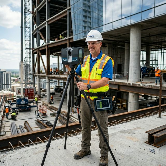
Serving Greater Los Angeles, OC, & IE

High-Precision
Digital Twins in LA

Accuracy Guaranteed to 2mm.

We deliver high-fidelity Point Clouds and As-Built documentation for renovation, architectural design, and construction quality control. Capture reality "as-is" with 1/8" precision.

1/8"
Max Deviation
10k
Sq Ft per Day
BIM
Ready Models

Get a Free Object Estimate

100% confidential. NDA available.

Why Architects & Contractors Trust Us

We don't just hand you a raw point cloud. We deliver clean, project-ready documentation so your team can start designing immediately.

Revit BIM Ready

We process raw point cloud data into fully structured Revit models, floor plans, and as-built drawings — not just a raw scan file you'd need to interpret yourself.

100% Confidential

NDAs are signed before any site visit. Your architectural data, floor plans, and proprietary facility layouts are processed securely and never shared.

10,000 Sq Ft per Day

Our mobile LiDAR team covers up to 10,000 square feet of floor area per day — minimizing site disruption for occupied buildings, hospitals, and retail spaces.

Eliminate Manual Measurement Risks

Tired of "Floating" Measurements?

Tape measures and manual levels lead to cumulative errors that always "float" in final drawings. We lock in the entire structure with millimetric precision.

Fabrication Reworks?

Steel structures or custom millwork failing to fit existing openings? Our scans provide the exact geometry to ensure a "first-time" fit every time.

Missing Documentation?

Need to renovate an old property with no existing blueprints? We generate a complete digital twin, serving as a clean slate for your new design.

The Solution: We fix reality "as it is" using state-of-the-art LiDAR scanning equipment.

Specialized AEC Solutions

3D Laser Scanning

Rapid data capture of entire buildings, generating dense, accurate point clouds. Perfect for large-scale area mapping and interior/exterior layouts.

Scan-to-BIM / CAD

Transform raw scan data into professional models. We provide Revit (.RVN), ArchiCAD, and AutoCAD (.DWG) files ready for immediate design work.

Construction Verification

Validate built status against design blueprints. Identify deviations in structural steel, piping, or concrete before they become expensive problems.

REALITY CAPTURE: LiDAR ACTIVE Initializing Scan... POINTS: 0

Tailored for Industry Leaders

  • Architects & Designers: Skip days of manual measuring. Get a perfect digital reference and focus on creativity.
  • General Contractors: Document utilities and MEP before closing walls or pouring concrete. Avoid "clashes" later.
  • Steel Fabricators: Ensure an ideal fit for structural members in existing spaces. Eliminate field modifications and downtime.

Technical Benchmarks

±1/8"

Engineering Accuracy

We use Faro Focus laser scanners to maintain absolute precision over large distances.

1-Day

Rapid Capture

We can scan up to 10,000 square feet in a single working day without stopping construction.

Native

Cloud Support

Data delivered in .RCP, .E57, .DWG, or .RVN — ready for your native CAD pipeline.

The 4-Step Success Path

01

Site Visit

We arrive at your object at the scheduled time, mapping out the scan plan.

02

Data Capture

Fast scanning without halting work. We move around your crew seamlessly.

03

Processing

Scan registration, data cleaning, and point cloud alignment in our lab.

04

Delivery

You receive your finished model or cloud. Immediate support for import issues.

Why Engineering Credentials Matter

Most scanning companies send entry-level technicians. At Replix3D, every project is handled by a **Certified Professional Engineer** with a valid license.

The Engineering Guarantee:

"Our licensed background ensures a deep technical understanding of your vision and **100% precise execution** according to your Technical Specifications (TS). We speak the language of blueprints, load-bearing structures, and complex MEP systems."

GC License #1110475 — Professional Engineering Standards
Licensed AEC Engineer with 3D Scanner
LICENSED EXPERTISE #1110475

Secure Your AEC Scan

Tell us about your project or object. Get a response within 4 working hours.

Honest Answers to Your Questions

Transparent information to help you plan your AEC project with confidence.

Is the 2mm accuracy guaranteed for entire buildings?

+

Yes, locally. For large structures, we use surveyed control points to prevent drift across the entire site, ensuring the global model remains precise.

How does your scanning handle busy construction sites?

+

We scan around site activity. Our LiDAR technology filters out moving people and machinery, so we don't require you to stop work.

Can you scan at night or in low-light conditions?

+

Yes. Our laser scanners do not require ambient light. We frequently perform scans at night to minimize site disruption.

What if I only need specific areas scanned, like a ceiling plenum?

+

We can perform targeted scans. Whether it's just the MEP infrastructure or a specific floor level, we tailor the scope to your needs.